
Tabula Rogeriana
Item


- Title
- Tabula Rogeriana
- AKA /name in common usage
- Nuzhat al-mushtiiq
- Type
- Map
- Creator
- Muhammad al-Idrisi
- Era
- Medieval
- Date Created
- 1154
- Date Modified
- ca.1300 (this version)
- Region and/or country
- Sicily
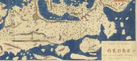
- Short Overview
- The most accurate map of its day, drawn by Arabic geographer Al-Idrisi, for Roger II of Sicily--hence its title. It is a "South up" map: visibly mending northern hemisphere bias.
- Longer description
- Abu Abd Allah Muhammad al-Idrisi al-Qurtubi al-Hasani al-Sabti, known as al-Idrisi's, Tabula Rogeriana was redrawn by Konrad Miller in 1929--the second image here. On this, the Arabic text was transliterated into Latin, not completely accurately. In a kind of reverse mending, its most widely available version, on Wikipedia, has been 'corrected' by being flipped to Northern orientation. The main image here is the copy dated around 1300 held by the Bibliotèque Nationale. The map location below is a random spot in al-Idrisi's birthplace in the city of Ceuta, now in Spain.
- Identifier
- ark:/12148/btv1b100601717
- Rights
- Public Domain
- Source
- Bibliothèque nationale de France
- Item sets
- Images


This item was submitted on July 23, 2022 by [anonymous user] using the form “Application Form for Images” on the site “Visible Mending”: https://visiblemending.org/s/world
Click here to view the collected data.