
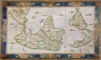
Planisphère A Dieppe par Nicolas Desliens, 1566
Item

- Title
- Planisphère A Dieppe par Nicolas Desliens, 1566
- AKA /name in common usage
- World Map, 1566
- Type
- Map
- Medium
- Vellum/ parchment
- Creator
- Nicolas Desliens
- Era
- Early Modern
- Date Created
- 1566
- Region and/or country
- Dieppe, France
- Short Overview
- Portolan world map synthesizing Norman hydrographic knowledge in the mid-16th century. It is "South up:" a visual that mends modern northern hemisphere bias.
- Longer description
- This is one of two world maps by Desliens known to exist; the other dates from 1541. La Nouvelle France occidentalle (Western New France) is written in large letters over an arc-shaped newly "discovered" North America, reflecting political bias of the time. Territories claimed by France are indicated by flags with fleurs-de-lis, in Canada (Labrador), Florida (on the May River), and Brazil (on the Rio de la Plata). Desliens is known only from his work and inscriptions on his maps indicating that he worked in Dieppe (hence the map locator) and Arques; no biographical information about him survives. (Information from Library of Congress)
- Identifier
- ark:/12148/btv1b55002609p
- Provenance
- Previous owner Viel-Castel
- Rights
- Public Domain
- Source
- Bibliothèque nationale de France, GED-7895 (RES)
- Item sets
- Images

This item was submitted on July 23, 2022 by [anonymous user] using the form “Application Form for Images” on the site “Visible Mending”: https://visiblemending.org/s/world
Click here to view the collected data.